When most users first make the move from Second Life to OpenSim, they have two main concerns: will they be able to find a community, and will they be able to find the stuff they want?
When an organization — a school, a company, a government agency — makes the move, however, it typically brings the community with it, in the form of students or employees.
Content remains a problem, however. Bringing stuff over from Second Life can be difficult, and even impossible in some cases.
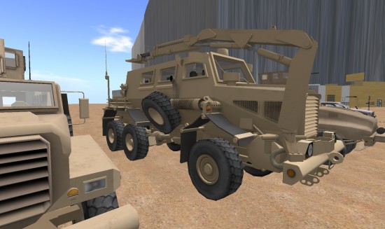
The US Army Research Laboratory Simulation and Training Technology Center launched its MOSES grid in early 2011. The content for that grid came from mesh uploads, generated from actual terrain data, created by grid users, and downloaded from Linda Kellie’s website.
Mesh objects
OpenSim has long supported mesh uploads, but the technology didn’t start catching on with grids until Second Life added mesh support to its viewers. OpenSim had Second Life-compatible meshes the day after the Lindens opened up their mesh data.
This is great for the military, since it already has a lot of content in 3D format.

According to Douglas Maxwell, the science and technology manager for virtual world strategic applications at the U.S. Army’s Simulation & Training Technology Center, MOSES supports the Defense Department’s Advanced Distributed Learning 3D Depository, where all the content is free to use, and Creative Commons licensed.
“Many of our in-house developed models can be found here,” Maxwell said.
OpenSim Creations has a nice explanation of how to upload mesh objects, or you could watch this tutorial video from the University of the Aegean in Greece. The mesh objects have to be in the Collada format, which has the .dae file type extension. Autodesk has a free format converter here, called the FDX Converter.

Real terrains
OpenSim comes with a default region terrain — a little circular island. There are also tools built into the viewer for manually adjusting the terrain. There are also online websites where folks can download a few other terrains as well. See our article, Where to get content for OpenSim.
But the military needs more than a few pretty island landscapes.
“If you are simply training for procedural knowledge, then the area doesn’t have to be accurate,” said Maxwell. “If you are training for a specific mission, then the virtual environment has to be highly accurate.”
However, traditional methods of creating accurate terrains were costly and time consuming, he added. So the MOSES team had to create its own method.
“We have developed a semi-automated process that ingests data from both military and civilian sources,” he said. This process takes in digital terrain elevation data from the Defense Department’s National Geospatial-Intelligence Agency and digital elevation models from the US Geological Survey, he said.
One benefit of working in OpenSim is that terrains can be changed in real-time, he added.
“Using scripts, we can create craters in response to explosive detonations,” he said. “We can also move the explosives to any place in the sim. Â This means the training scenario can be randomized and the students cannot ‘game’ the system. Â For example, let’s discuss a hypothetical convoy driving scenario that tests your ability to spot signs of IEDs. Â If you know that every time you enter the town square there will be an explosive, then the test is of your memory of the location and not the signs of an IED.”
Moving scripted objects is easy in OpenSim and doesn’t require developers or 3D artists — just the ability to right-click on an object and click on the arrows to move it to a new location. This is a major advantage of OpenSim over some of the high-end virtual environments and training platforms.
“Current training systems are not flexible enough to allow the trainer to move events to any other place in the simulation,” he said. “It is all pre-scripted and canned.”
In-world editing
The traditional development process for a training simulation starts with 3D modeling in Maya or 3DS Max and Photoshop, which generally requires a professional content company. Then this 3D content is imported into a world building tool which is specific to the chosen game engine. Then lighting is added and the world is compiled into a level, which is then added to the game. The whole thing is then deployed to a game server.
“OpenSim is admittedly low fidelity, but the content creation process is vastly simplified,” Maxwell said. “Content creators have the option of using offline 3D modeling tools, but they can also work in prims for a quick and dirty solution.”
Then, after the content is created, authorized users can easily move it to desired locations and combine it with other content — all in real time.
“The holy grail of simulation-based training initiatives is to have an editing capability that is at the level of complexity of PowerPoint ” Maxwell said. “The trainers are the subject matter experts in their instruction.  We would much rather have them create the environments to their satisfaction.”
Off-the-shelf and ready to wear
OpenSim also benefits greatly from having a large library of pre-made content — avatars, clothing, buildings, animations and a lot more — freely available for any use whatsoever. The original creations, all made by Linda Kellie, come with no licensing or use restrictions, making them the perfect choice for organizations looking to outfit a new grid.
Her site includes individual downloads of hundreds of items, as well as more than a dozen fully-made regions in the form of OAR files. These regions are landscaped, stocked with buildings and scripts, and can be quickly and easily uploaded to a grid. For example, her Freebie Mall region comes with more than 23,620 prims worth of goodies.
“Linda Kellie’s work is high quality and I’m a big fan,” Maxwell said. “Her OAR files have provided the MOSES residents with clothing and basics.”

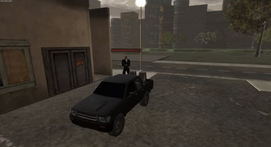
For example, Linda Kellie’s urban OARs were used as settings for urban combat scenarios, he said. “Using the content was a cost and time savings.”
One such OAR is the Urban City region, available as a free download here.
- International singers gather on Alternate Metaverse Grid for first annual International Day - April 15, 2024
- OpenSim hits new land, user highs - April 15, 2024
- Wolf Territories rolls out speech-to-text to help the hearing impaired - April 15, 2024
